AI for urban vegetation and human health

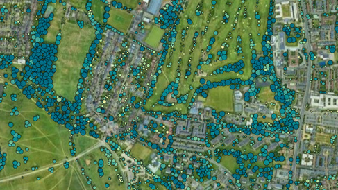
This research explores the application of big data, Artificial Intelligence (AI), and Machine Learning (ML) to map and analyse urban green ecosystems with a focus on equity and health. The core objective is to develop a novel, high-resolution green ecosystem dataset that defines green space systems through measurable equity metrics—enabling cities to assess and act on spatial inequalities in urban greening. It aims to model the role of vegetation in regulating urban climates and improving human health, using several sources of information, including weather and climate data, remote sensing products and census and survey data (socio-economic and health indicators).
A central focus is the operationalisation of the 3:30:300 rule, which posits that every resident should be able to see at least three trees from their home, enjoy 30% tree canopy in their neighbourhood, and live within 300 metres of a quality green space. Using satellite imagery, LiDAR data, street-level views, and demographic information, AI models will classify and quantify green infrastructure across diverse urban settings. Machine Learning algorithms will be used to generate spatially explicit indices of green access, quality, and canopy cover, while equity metrics will be derived by correlating these indices with socioeconomic data. The research will characterise urban areas based on green infrastructure metrices like the 3:30:300 rule and assess how disparities.
The outcome will be a scalable tool for city planners and policymakers to visualise, prioritise, and target green space interventions. By embedding fairness in green infrastructure planning, this research supports climate adaptation, mental and physical health, and social resilience in rapidly urbanising regions.
Publications
Zuñiga-Gonzalez, A., Madhavapeddy, A., and Bardhan, R.: Green Urban Equity: Analyzing the 3-30-300 Rule in UK Cities and Its Socioeconomic Implications, EGU General Assembly 2024, Vienna, Austria, 14–19 Apr 2024, EGU24-20833, https://doi.org/10.5194/egusphere-egu24-20833, 2024.
Zúñiga-González, A., Millar, J., Sethi , S., Haddadi, H., Dales , M., Madhavapeddy, A., & Bardhan, R. (2025). From Ground to Canopy: Integrating Ground-based Sensors with Remote Sensing to Improve Urban Tree Management. Presented at the BioSpace25 - Biodiversity insight from Space, Florence, Italy. https://biospace25.esa.int/wp-content/uploads/2025/02/Conftool_agenda_forPrint.pdf
Zúñiga-González A.C., Madhavapeddy A, Bardhan R. 2025. Scaling the Urban Forest: An Integrated Framework for Managing Cities by Fusing Raster and Vector Data. PROPL25 (Programming for the Planet) at ICFP/SPLASH
Team
| PhD Researcher | Andres Zuñiga-Gonzalez |
| Supervisor | Professor Ronita Bardhan, University of Cambridge, UK |
| Co-supervisor | Prof. Anil Madhavapeddy, University of Cambridge, UK |
